
In recent years, the mighty California Department of Water Resources has committed to researching the possibility of extending weather forecasting beyond the 3-14 days that is currently “skillful” according to statistical measures. In the fall they have been hosting a discussion of these questions at the National Academy of Sciences outpost at UC Irvine. This year’s presentation was called Water Year 2019: Feast or Famine?
Without getting into a long and wonky discussion, suffice to say that researchers seem to have turned away from the past emphasis on the influence of El Nino on precipitation in the Southwest, and instead are pioneering new methods, working with the support of NOAA, focused on the identification of specific “weather objects” such as Atmospheric Rivers nearer the West Coast. (see forecasts here)
State climatologist Michael Anderson warned the audience of scientists to take this “outlook” with “a whole shaker of salt,” and included this slide, discussing conditions and factors forecasters must consider.
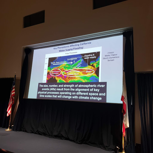
Anderson admitted a little later that the amount of information in that slide might have been “abusive.”
Nonetheless, he went on to summarize the outlook for rain and snow as follows. These are some of CA’s best forecasters making observations about what they’ve seen so far from this water year. Notes in [brackets] are my off-the-cuff translations of the science
Slow start to water year: no significant precipitation until Thanksgiving. [factor in wildfires]
Eastern Tropical Pacific warmer than usual [meaning more clouds closer to West Coast — potential moisture]
Jet stream zonal [systems moving directly across Pacific, east to west, and rapidly]
“pattern suggests faster moving storms regularly impacting California with precipitation totals dependent on AR [Atmospheric river] characteristics — watch your weather forecasts”
Dynamical seasonal forecast suggests above average winter [but these forecasts have not been shown to have skill]
NOAA forecast calls for wetter than average winter
Sounds to me like these folks are expecting a wet winter, even if they don’t want to be quoted saying so.
This morning the LA Times reports that the storm system that hit SoCal this week was wetter than expected, and veteran observer (and friend) Bill Patzert puts that in context:
There are a couple of reasons why it’s hard to say whether the rest of the season will be rainy.
Not only is there a “wannabe” El Niño in the Pacific Ocean along the equator, a weather phenomenon that can cause a series of subtropical storms to hit California, Patzert said, but there’s also a “blob” of warm water in the northeastern Pacific Ocean, which in years past has reinforced a drought-worsening ridge of high pressure that diverts storms away from the West Coast and into the central United States.
“It’s a rematch of the blob versus El Niño,” Patzert said. “Most forecasters are being cautious about January, February and March, which are usually our wettest months.”
As the story notes, one reason it may feel wetter than normal is that it’s been much drier than normal in recent years, especially early in the season. (Last year at this time SoCal had recorded only a trace of moisture.) This year so far we’ve had about 4 inches here in the Ojai area. So it seems wetter.
